

At 4,693 meters, the Khunjerab Pass is one of the highest paved border crossings on Earth — the roof of the Karakoram where China meets Pakistan along the fabled Karakoram Highway (KKH). Driving it is the most extreme, most “edge of the map” experience Xinjiang offers: a climb through the Pamir to a border post where the air is thin and the silence is total. This guide covers the route, the permits, and the hard truths — because this one is not casual.
First, manage expectations
Most travelers do the Kashgar → Tashkurgan → Karakul leg (our Tashkurgan guide covers it) and turn back — which is spectacular and achievable. Actually crossing into Pakistan requires a valid Pak-China route plan, Pakistani visa, and usually a guided/bussed arrangement; self-driving across is rare and heavily restricted. So this guide covers the drive to the pass vicinity (the experience) and what’s needed if you intend a crossing.
The route: Kashgar → Tashkurgan → Khunjerab
- Kashgar → Tashkurgan: ~190 km on the G314/KKH, 4–5 hours with stops. Requires a Border Defense Permit (see the checkpoint guide).
- Tashkurgan → Khunjerab Pass: ~130 km further, climbing to the border. The road is paved but high and exposed.
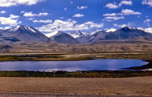
- Highlights en route: Baisha Lake, Muztagh Ata, and Karakul Lake — the Pamir wall in full.
Permits and the crossing
- Border Defense Permit: obtain in Kashgar (or Urumqi) a day or two ahead; routine but not instant. Carry passport always.
- Crossing into Pakistan: requires a Pakistani visa and, in practice, coordination through a tour operator — independent self-drive crossings are not the norm. Confirm current rules; they shift with bilateral conditions.
- Checkpoints: frequent and professional on this corridor; have documents ready.
Altitude: the real challenge
Tashkurgan sits near 3,100 m; the pass tops 4,690 m. Altitude sickness is a genuine risk:
- Ascend gradually; the Kashgar night (≈1,300 m) to Tashkurgan jump is significant.
- Hydrate, avoid alcohol the night before, and watch for headache/breathlessness.
- If you feel unwell at altitude, descend — don’t push to the pass.
- The packing list includes layers for the cold up high.
When to attempt it
The pass is seasonal — typically open roughly May/June through October/November, closed by snow in deep winter. Even in season, weather can close it temporarily. The best-time guide and summer road alerts track openings. Never assume it’s open; check the morning you plan to go.
Driving the KKH
- Paved but narrow in places, with switchbacks and occasional rockfall zones.
- No guardrails in spots; exposure is real. Daylight and sober only.
- Fuel: full tank in Kashgar; Tashkurgan has fuel but don’t count on the pass.
- An SUV is appropriate; see the vehicle guide.
What you’ll feel
The Pamir doesn’t perform for you — it simply is, vast and indifferent and beautiful. At the pass, there’s a marker, some wind, and the sense that you’re standing on a seam of the planet. Most people don’t cross; they come this far, breathe the thin air, and turn back changed. That’s enough.
FAQ
Can I self-drive across to Pakistan? Generally no as an independent traveler; crossings are arranged via operators with proper visas. Confirm current rules.
Do I need a permit for Tashkurgan? Yes — the Border Defense Permit. Kashgar issues it.
Is altitude dangerous? It can be — ascend slowly, hydrate, and descend if unwell.
When is the pass open? Roughly summer through autumn; closed in deep winter by snow.
Final word
The Khunjerab drive is the roof of the Xinjiang road trip — high, raw, and humbling. Reach Tashkurgan, see the Pamir wall, and decide how far the thin air lets you go. The border is a line; the mountain is the point.
Written by Karl Huang, a Xinjiang-based travel writer. Border crossing and permit rules change frequently — confirm with Chinese and Pakistani authorities before any attempt.