

Not every great Xinjiang drive is a remote mountain pass. Some are short, smooth, and so visually striking they become destinations in their own right. The Sayram–Guozigou section of the G30 expressway is exactly that: a 30-odd-kilometer ribbon of viaducts and tunnels that carries you from the green heart of the Ili Valley, through the narrow Guozigou gorge, and out onto the shore of Sayram Lake — the “last drop of the Atlantic” and the largest alpine lake in Xinjiang.
It is the easiest “wow” drive in the north, and the perfect first or last leg of any Yili grassland loop.
What this road is
This is the Guozigou segment of the G30 Lianyungang–Khorgos expressway, the main east–west artery that ultimately reaches the Khorgos border with Kazakhstan. The headline structure is the Guozigou Bridge — a cable-stayed viaduct that arcs high above the gorge, often cited as one of the most beautiful bridge approaches in China. The whole section is toll expressway: fast, lit, and engineered to a very high standard.
Unlike the Duku or the Yizhao, there are no seasonal closures here for snow in the same way — the expressway is maintained year-round, though winter driving still demands caution on the passes.
The experience, west to east (or reverse)
Most travelers approach from the Ili side (Yining / Khorgos) heading east toward Sayram, or the reverse on the way out.
1. Leaving the valley. Past the orchards and canal country, the road begins to rise. The gorge narrows, the rock walls close in, and the first viaducts appear.
2. The Guozigou Bridge. The moment people stop for. From the bridge you look down into a deep green gorge threaded by a river, spruce climbing the slopes on both sides. There are designated viewpoints and a service area where you can pull off and photograph the span — do not stop on the bridge itself.
3. The climb to the lake. Beyond the gorge the road tops a pass and the world opens onto Sayram: a vast sheet of blue ringed by snow mountains, often with a bank of cloud or a rare bit of “lake light” that turns the water silver.
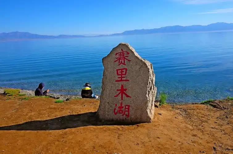
Pairing it with Sayram Lake
The road exists to deliver you to Sayram Lake, and the two should be planned together. Practical notes:
- Ring road around the lake. A scenic loop road runs the shoreline with multiple pull-offs. Budget 2–3 hours to drive it slowly and stop.
- Wind. Sayram sits in a wind corridor; it can be dramatically colder and breezier than Yining 40 km away. Pack a windproof layer even in July.
- Season. June–September is ideal. In early summer the surrounding meadows burst with wildflowers; late September brings golden light. Winter is stark and beautiful but very cold, with possible closures in heavy snow.
- Tickets. The lake is a managed scenic area with an entry system; check current rules and carry ID/passport at the gate.
Driving and toll tips
- It’s an expressway. Observe the speed limit (clearly posted), use the right lane, and watch for the many tunnels — light adaptation matters.
- Fuel and rest. Fill before leaving Yining; there are service areas but they can be busy in peak season.
- Cashless tolls. Most sections use electronic tolling; if you’re in a rental, confirm with the rental company how tolls are handled. Our fuel and toll guide for Xinjiang covers the practicalities.
- Foreign drivers: valid license and temporary permit required, same as anywhere; routine checkpoints at the scenic-area gate.
Why it matters for your route
The Sayram–Guozigou road is the connective tissue of northern Xinjiang. It links the Ili Valley, Sayram, the Yizhao Highway to Zhaosu, and the road east toward Urumqi. If you’re building an Xinjiang road trip itinerary, this short section will likely appear at least twice — and it never gets old.
FAQ
Is the Guozigou Bridge open in winter? The expressway is maintained year-round, but winter weather can slow or briefly close the high pass. Check before travel.
Do I pay a toll? Yes — it’s a toll expressway. Tolls are modest for the distance.
Can I photograph the bridge? Yes, from the designated viewpoints and service area. Never stop on the bridge deck.
How long is the drive from Yining to Sayram? About 1.5–2 hours including the gorge and a stop at the viewpoint.
Is it worth it if I’m short on time? Yes — it’s the highest-impact short drive in the north and pairs perfectly with the lake.
Final word
The Sayram–Guozigou highway proves you don’t need a remote pass to feel the scale of Xinjiang. Thirty kilometers of gorge, bridge, and alpine lake is enough to reset your sense of what a “road” can be. Make it the bookend of your Ili trip — once on the way in, once on the way out.
Written by Karl Huang, a Xinjiang-based travel writer. Toll and scenic-area rules change — confirm with local authorities before you travel.