

The Kashgar to Karakul Lake drive is the most scenic single day in Xinjiang: you leave a Silk Road oasis and end beneath 7,500 m peaks on the Roof of the World. It is the core of any Karakoram Highway self-drive. Here is the route and the altitude math.
Route (G314 south)
- Kashgar (1,290 m) → Upal: First checkpoint zone; fuel and last big supplies.
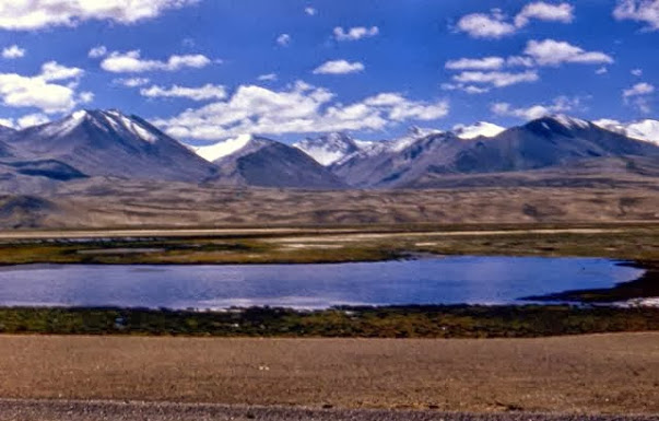
- Upal → Bulunkou / Karakul Lake (3,600 m): Climb onto the Pamir. Karakul, a glacial lake under Muztagh Ata, is the headline.
- Optional onward to Tashkurgan (3,090 m): The county seat near the border.
Total Kashgar→Karakul ~190 km, ~4 hours with checks and photos.
Altitude Profile & Acclimatization
You gain ~2,300 m in a few hours — fast. Tips:
– Spend a night in Kashgar (1,290 m) first.
– At Karakul, move slowly; mild headache is common.
– Descend if symptoms worsen. Our safety guide covers altitude.
Must-Stop Viewpoints
- Bulunkou Lake viewpoint en route.
- Karakul north shore for Muztagh Ata reflection shots.
- Panlong Ancient Road detour if your permit and time allow (see the Panlong guide).
Overnight Options
Karakul has yurt stays and a basic hotel; Tashkurgan has more choice. Book ahead in summer. The border pass guide explains the permit you need before starting.
FAQ
Is one day enough for Kashgar→Karakul→back?
Yes for the lake and return, but it is a long day. Staying overnight at Karakul or Tashkurgan is far better.
Do I need the border permit even if I turn back?
Yes — Karakul is inside the Pamir permit zone. Get it in Kashgar first.
When is the road best?
June–September for open passes and clear peaks. Winter is harsh and some stretches close.