

Few journeys reward a driver like a Xinjiang road trip. China’s largest province is bigger than Western Europe, yet its landscapes compress a lifetime of geography into a single tank of gas: glacial lakes, rainbow mountains, endless deserts, and Silk Road oasis towns where languages and cuisines blend at every stop. This guide gives you a ready-to-drive xinjiang road trip itinerary — a 14-day grand loop you can trim to 10 days — plus the practical backbone (licenses, car rental, seasons) you need before you turn the key.
Why Drive Xinjiang?
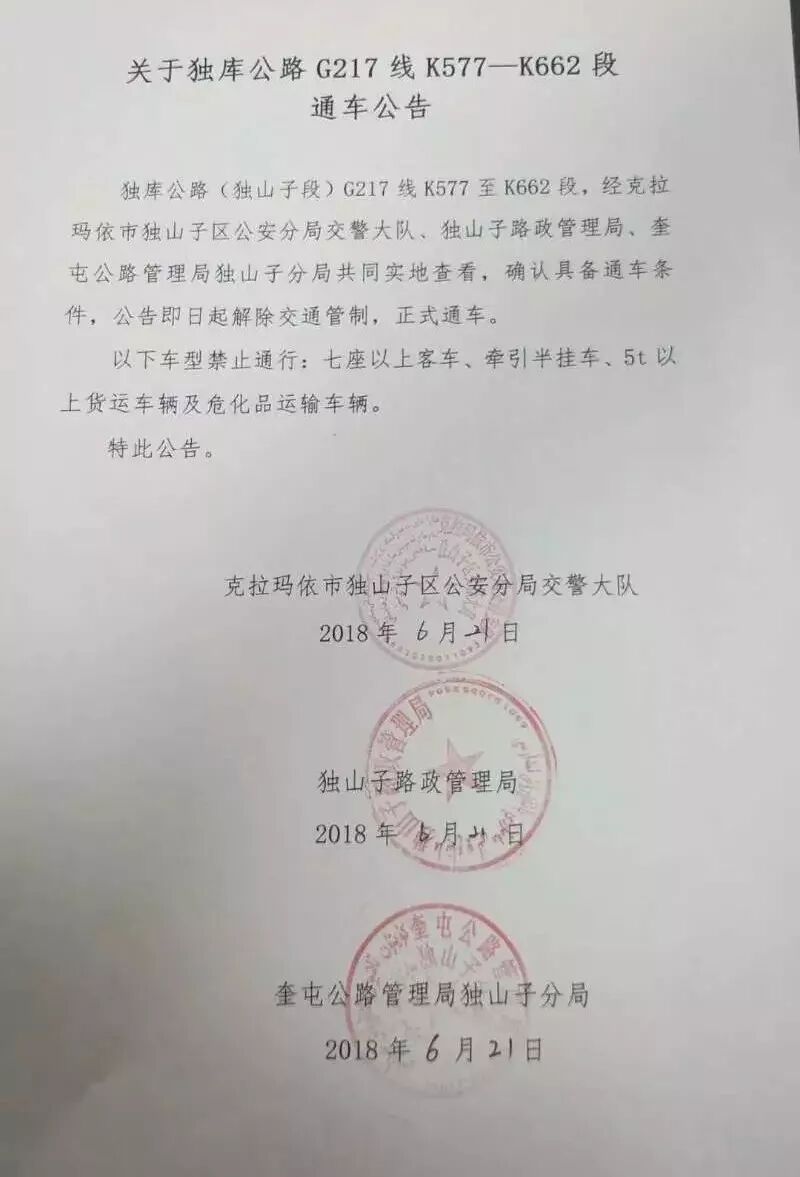
Public transport connects the big cities, but the soul of Xinjiang lives on the roads between them. The best xinjiang road trip route is the one that strings together the iconic passes — the Duku Highway, the Yizhao Highway, the Karakoram — roads that close for snow half the year and open like gifts in summer. Driving lets you stop at a turquoise lake at 11 a.m., eat lamb noodles in a Uyghur town at 1 p.m., and sleep in a wooden cabin beneath a glacier by night.
Most travelers start their xinjiang road trip from Urumqi, the provincial capital and the main international flight hub. From there the province splits naturally into two arcs:
- Northern Xinjiang — alpine lakes (Kanas, Sayram), grasslands (Nalati, Bayinbuluke), and the Duku Highway.
- Southern Xinjiang — the Tarim Basin, the Taklamakan Desert, Kashgar, and the Pamir Plateau.
A full xinjiang loop road trip map covers both, but that is 3,000+ km of driving. If you have 10 days, pick one arc. With 14, do the grand loop below.
The 14-Day Grand Loop (trim to 10)
| Day | Route | Drive (km) | Overnight |
|---|---|---|---|
| 1 | Urumqi → Tianchi → Urumqi | 120 | Urumqi |
| 2 | Urumqi → Sayram Lake | 540 | Sayram |
| 3 | Sayram → Yining (via Yizhao Hwy) | 200 | Yining |
| 4 | Yining → Nalati Grassland | 250 | Nalati |
| 5 | Nalati → Bayinbuluke | 80 | Bayinbuluke |
| 6 | Bayinbuluke → Duku Highway → Kuqa | 360 | Kuqa |
| 7 | Kuqa → Aksu → Kashgar | 700 | Kashgar |
| 8 | Kashgar → Karakul Lake (Pamir) | 190 | Tashkurgan |
| 9 | Tashkurgan → Kashgar | 190 | Kashgar |
| 10 | Kashgar → Hotan (desert highway) | 500 | Hotan |
| 11 | Hotan → Aksu | 550 | Aksu |
| 12 | Aksu → Korla → Turpan | 700 | Turpan |
| 13 | Turpan → Urumqi | 200 | Urumqi |
| 14 | Buffer / flight out | — | — |
10-day cut: drop Days 10–12 (the southern desert leg) and return from Kashgar by flight, or skip the Pamir if you cannot get the border permit in time.
Route highlights you shouldn’t skip
Northern arc. The northern Xinjiang road trip loop is the most scenic for first-timers: Sayram Lake’s wind-battered shores, the vertical drama of the Yizhao Highway, and Nalati’s aerial meadows. Save the driving the Duku Highway segment for Day 6 — it is the single most beautiful day of road in China, climbing from flaming red canyons to snow-fed passes in under 200 km.
Southern arc. The southern Xinjiang self-drive route is harsher and more profound: the Taklamakan Desert highways, the living museum of Kashgar Old City, and the Pamir Plateau where the Karakoram meets the Hindu Kush. You will need a border defense permit for the Pamir — plan it two weeks ahead.
When to go
Timing makes or breaks the trip. The best time of year for a Xinjiang road trip is June–October. The Duku and Yizhao highways typically open in early June and close by late September–October depending on snow. Autumn (September–October) is the photographic peak — golden birches around Kanas, blue skies over the Pamir.
Getting a car and a license
You cannot legally drive in China on a foreign license alone. Before you book, read our guides on Xinjiang driving license requirements for foreigners and the temporary driving permit process. Most visitors either rent a car with a driver or rent a self-drive car and obtain the permit in Urumqi or border cities. Budget roughly ¥400–900/day for an SUV, plus fuel and tolls.
Packing & permits checklist
- Passport + China visa (or eligible visa-free transit)
- Temporary driving permit + translated license
- Border Defense Permit for Pamir/Tashkurgan
- Offline maps (Gaode/AMap; Google Maps is unreliable inland)
- Cash for remote tolls and small towns
- Layered clothing — temperatures swing 20°C between noon and pass-top
FAQ
Can I do this trip in winter? Only the southern desert leg and Urumqi surroundings. The Duku, Yizhao, and Pamir roads close for snow.
Do I need a 4×4? An SUV is enough for paved highways. A true 4×4 helps only on occasional rough access roads to trailheads.
Is it safe? Yes — read our full Xinjiang road trip safety breakdown. Checkpoints are routine for all travelers; carry your passport.
Final word
A Xinjiang road trip is a logistical adventure, but the payoff — a glacier at dawn, a desert at dusk — is unmatched. Start with the loop above, then branch into our deep-dive guides on each highway, lake, and town.
Written by Karl Huang, a Xinjiang-based travel writer. Always verify permit and road-opening rules with local authorities before departure.